Seasonal Forecasts for the Midwest: Why Dynamic Models Fail Us
This is the start of a Blog Series, where we will introduce our model and begin giving monthly seasonal forecasts for the Midwest US, with specific emphasis on Agricultural needs. Keep an eye out for our December outlook soon!

What is a Seasonal Forecast?
Even with the great strides in Forecast Model Advancement, seasonal forecasts are incredibly difficult. Trying to accurately capture variations of temperature and precipitation for a region for an entire season (from as little as 2-weeks to as far ahead as several months) involves tracking the impacts Sea Surface Temperature (SST) on atmospheric dynamics across the globe. What makes this tricky is that the impact SST has on a region is often indirect. More importantly, the impact changes from region to region. This means, model set-ups that work well for one region, likely will not work for another.
Therefore, ensembles are so important when it comes to seasonal forecasting. Looking at a variety of models that emphasize various dynamical processes is key to understanding the impact of SST on climatological norms for an area of interest. Some organizations provide these forecasts for free, such as the Copernicus Programme (which includes the ECMWF products), the International Research institute for Climate and Society and the S2S Predication Project.
Why is the Midwest A Difficult Forecast?
The Midwest US is particularly difficult for seasonal forecasts, even for very short-term scales. We believe that dynamic forecast models struggle with this region particularly because the connection between SST anomalies and the impact on Midwest’s seasonal temperature and precipitation variations is extremely weak.
Why is this the case? Simply stated: Geography.
The Midwest US is effectively cut off from direct ocean dynamics. We have the Rocky Mountain range to the west, the Appalachian Mountain range to the east, and a massive, friendly land mass to the north (Hello, Canada!).
The only ocean influence we have is the Gulf of Mexico. While it is extremely important for our synoptic weather, the gulf does not have those dynamic variations in SST that other, larger oceanic regions do, like ENSO, NAO, or PDO. Since seasonal forecast models all use SST as the initial condition, these dynamic models are about as useful for the Midwest US as a coin flip.
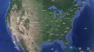
Image courtesy of Google Earth.
What are the alternatives?
However, this doesn’t mean that there aren’t dynamic influences on seasonal variation for the Midwest. There most definitely is! The problem is that SST has such a weak influence on our seasonal weather patterns, that dynamic models would have to utilize a different variable to better capture the processes. The problem is identifying which variable that is, which takes time to do.
So, for now, we will table the use of dynamic forecast models for seasonal prediction in the Midwest US. We want to try different approaches that can be easily and quickly utilized so that our friends in Agriculture, Energy, and Transportation can have some useful information to go on as we approach winter and, eventually, the start of growing season. We have a statistical model that we find can provide far better forecasts for our region than dynamic models are currently capable of.
Keep an eye on this blog for our December outlook using our Statistical approach to seasonal forecasting!
